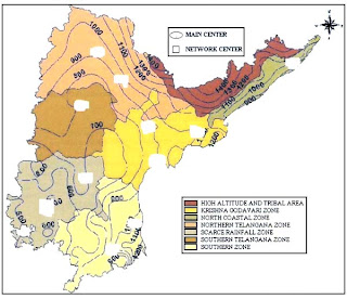
 Isohyets are contour lines on a map or chart connecting areas of equal rainfall. The Acharya N.G. Ranga Agricultural University (ANGRAU) has initiated a project aimed at improvement of water management in the State of Andhra Pradesh, India due to the limited availabilty of water since 2000. This map shows the Agro-climatic Zones with annual Rainfall (mm) Isohyets of Andhra Pradesh.
http://www.fao.org/docrep/009/a0415e/A0415E21.jpg

No comments:
Post a Comment